


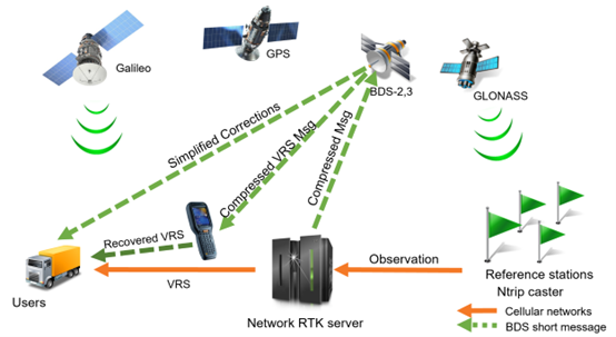
In the context of rapid urbanisation and smart city development, Hong Kong faces severe challenges in Global Navigation Satellite System (GNSS) positioning services: Current high-precision positioning services rely solely on terrestrial communication networks and support only the single GPS system, resulting in insufficient reliability in remote or offshore areas. These regions often struggle to obtain high-precision positioning due to incomplete terrestrial communication network coverage, constraining the development of key applications such as surveying, autonomous driving, and disaster management. The deployment of the BeiDou-3 (BDS-3) system brings new opportunities, with its multi-frequency signals and innovative short message communication (SMC) function providing significant technological breakthroughs for modern Positioning, Navigation, and Timing (PNT) services. This project constructs the first BDS-3-based augmentation system and, by integrating multi-satellite constellation resources, delivers decimeter- to centimeter-level high-precision positioning services. Leveraging the BeiDou short message communication capability, the system can break free from dependence on terrestrial communication networks, thereby significantly enhancing Hong Kong's geospatial resilience and service reliability in complex geographical and network environments.
The project's impacts extend beyond technical enhancements, establishing Hong Kong's pivotal role in multi-constellation GNSS development and generating broad socioeconomic benefits. At the local level, the system strengthens urban infrastructure by providing Real-Time Kinematic (RTK) and Precise Point Positioning (PPP) services that do not rely on mobile networks, supporting precise positioning needs in areas with weak communication. From a global perspective, as the first BDS-3-based augmentation system outside mainland China, this project offers a replicable model for Asia-Pacific economies facing similar coverage challenges, enhancing the availability and resilience of global navigation services and facilitating the construction of more integrated and efficient next-generation positioning solutions.
Prof. Wu Chen, Head (LSGI) & Chair Professor of Satellite Navigation, Department of Land Surveying and Geo-Informatics, The Hong Kong Polytechnic University