


Accurately predicting the powerful winds of tropical cyclones is critical for protecting lives and property, yet remains a significant challenge. Traditional weather models are detailed but computationally slow, while modern AI-based models offer speed but lack fine-scale detail and often underestimate peak intensity, partly due to biases in their training data. In contrast, satellite-based Synthetic Aperture Radar (SAR) provides a unique advantage: it penetrates storm clouds to measure ocean surface winds at a remarkably high resolution of approximately half a kilometer.
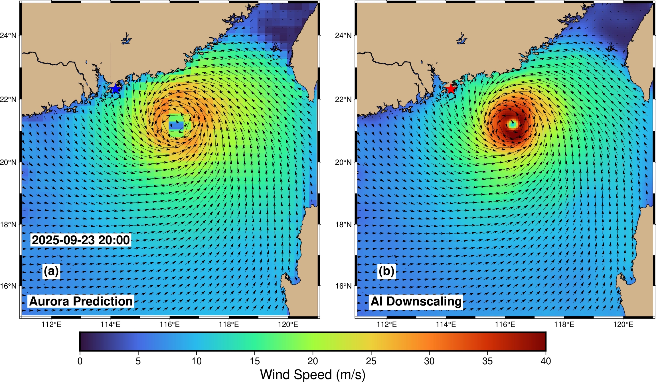
To bridge this gap, we developed HIWindCast, a novel hybrid approach that integrates the speed of AI weather models with the precise, high-resolution wind observations from SAR (Zhang et al., 2025). This fusion enables fast, yet substantially more accurate, forecasts to support critical decision-making by weather services. Designed for flexibility, HIWindCast can be coupled with various leading AI weather prediction systems. During Typhoon Ragasa (2025), it reduced maximum wind speed errors by up to 57% and errors in the radius of maximum winds by up to 70% across three different AI models. Based on these compelling results, HIWindCast has been adopted for operational forecasting by the Hong Kong Observatory (HKO) and the China Meteorological Administration (CMA).
In related work, we have successfully assimilated high-resolution SAR wind data into the Weather Research and Forecasting (WRF) model. The results confirm that incorporating this data significantly improves typhoon forecasting. For example, for Super Typhoon Doksuri (2023), assimilation of SAR winds can improve the accuracy of the predicted storm track by up to 25.9%. Forecasts of typhoon intensity also shows substantial gains, with errors in maximum wind speed reduced by up to 8.2% and in minimum sea level pressure by up to 15.0% (Gong et al., 2025).
Together, these studies demonstrate that integrating high-resolution satellite wind observations is a highly effective strategy for enhancing early warnings and preparedness for dangerous tropical storms. The operational value of these advanced models is also recognized by the energy sector, where offshore wind farms actively seek them to optimize power generation forecasts.
Publications:
1. Zhang, E., H. Su, H., P.W. Chan, C. Zhai, W. Zhou, W. Xu, M. Hu, X. Li, Y. Jia, and Y. Song, Deep learning‐based multisource satellite data fusion and downscaling for tropical cyclone wind fields. Journal of Geophysical Research: Machine Learning and Computation, 2, e2025JH000792.https://doi.org/10.1029/2025JH000792, 2025.
2. Gong, Y., H. Su, and P.W. Chan, Assimilating SAR high-spatial-resolution wind data to improve tropical cyclone forecasts. Journal of Geophysical Research: Atmospheres, 2025. (Under Review)
Prof. Hui Su, Chair Professor and Global STEM Professor, Dept. of Civil and Environmental Engineering, The Hong Kong University of Science and Technology