


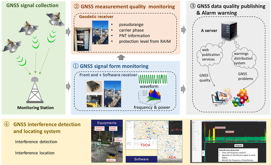
The Lands Department is actively developing the Global Navigation Satellite System (GNSS) infrastructure in Hong Kong to support a wide range of positioning, navigation, and timing applications. The current GNSS infrastructure provides public services such as Differential GNSS (DGNSS) and real-time kinematic (RTK) positioning, supporting all major satellite constellations including GPS, GLONASS, Beidou, and Galileo. These services have been widely adopted in high-precision applications across Hong Kong. However, the existing GNSS infrastructure is susceptible to frequent system failures and signal interferences, which can result in significant positioning errors or even complete loss of signal. Such disruptions can critically impact essential sectors like civil aviation, communication networks, and electric power systems. Therefore, it is vital to detect system failures and interferences promptly and to mitigate their effects on these critical applications.
To address these challenges, this project has established Hong Kong’s first GNSS signal quality monitoring and interference detection system. Specifically, the platform continuously monitors various aspects of GNSS signal quality, including signal strength, spectrum characteristics, ionospheric effects, observation data, and message anomalies. It provides real-time assessment of GNSS data quality and issues immediate warnings in the event of malfunctions. Since GNSS interference is one of the most significant threats to reliable positioning, the system is also equipped to detect and locate sources of interference, offering timely alerts to help troubleshoot problems and maintain stable GNSS services. By enhancing the reliability and robustness of positioning services, this system supports critical applications such as civil aviation, unmanned aerial vehicles (UAVs), and communication networks. This initiative meets the urgent need for a resilient GNSS infrastructure in Hong Kong, ensuring safer and more dependable navigation and timing services for the community.
Prof. Wu Chen, Head (LSGI) & Chair Professor of Satellite Navigation, Department of Land Surveying and Geo-Informatics, The Hong Kong Polytechnic University